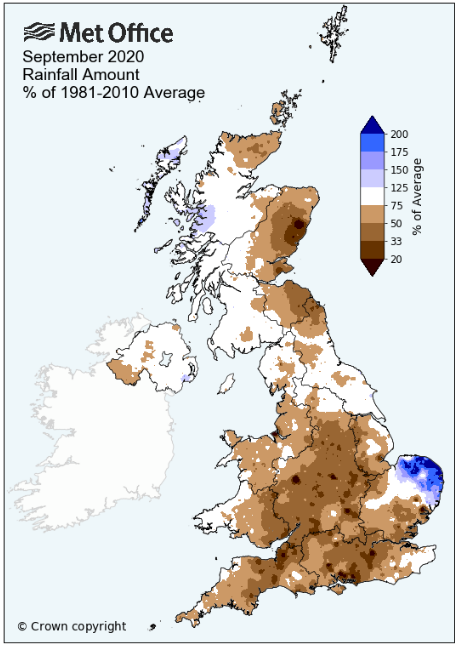
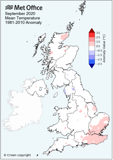
Drier and colder than average - number of ground frosts well above average
It was an unsettled start to the month, becoming more settled from the 9th, then dry from the 13th before the month turned cooler and less settled from the 22nd with a sharp drop in day-time temperatures and a number of nights having ground frosts.
During the month both the highest and lowest maximum temperatures for September (12 years of records) were recorded and we also recorded the most ground frosts (six) as well. Of these it was possibly that lowest maximum temperature record that was the most notable, as at just 9.1°c it was the first September day in my records that has failed to attain 10°c.
Whilst day-time temperatures were suppressed, it was the night-time minima that showed the greatest departure from the norm. There had been the occasional cooler night during the month, but from the 24th, there was a more sustained coolness about the nights and whilst we avoided air frosts, ground frosts became quite common.
No one single day experienced heavy rainfall, only two days topped 10 mm, with the 2nd - 6th and 22nd - 25th having the main bursts of rain. Whilst it was dry through the middle portion of the month, either side of these periods any rainfall was light and patchy in nature.
MSLP of 1016.5 Mb was +2.4 MB above the local average for the month and overall a mean minimum of 7.06°c and a mean maximum of 15.89°c saw the temperature 0.98°c below the eleven year average for this site.
It was the coldest since 2015 and of the twelve now recorded, ten have been warmer and just the one has been colder - the highest maximum temperature recorded being 25.7°c (15th), the lowest minimum 0.9°c (28th).
Rainfall of 70.0 mm (Maulds Meaburn North ++ 65.0 mm -- Castlehowe Scar 84.3 mm) was 78.1% of average for 2007-19 and made it the driest September since 2015. Of the fourteen now recorded, nine have been wetter and four have been drier.
During the month the wind speed averaged 6.80 mph, with a maximum gust of 45 mph (13th).
++ Replaces the rain gauge at Crosby Ravensworth School, which I found out of the ground during July. How, why and when I don't know, but I took the decision to discontinue the site; it had been established in August 2014.
With thanks to David, it is now to the north of the village and I'm expecting that it will record between 5-10% less than my own.
At the Met' Office site at Newton Rigg a mean temperature of 11.64°c is 0.7°c colder than average and is the coldest since 2015. In a series back to 1951, 18 have been colder and 51 have been warmer.
Rainfall totalled 82.0 mm (107.5% of average), making it the driest since 2016. Since 1900 when the record began (records don't exist in two years), 44 have been wetter and 74 have been drier.
At Appleby in Westmorland a total of 69.4 mm represented 90.2% of its average and made it the driest since 2015 - in a record that commenced in 1856, 86 have been wetter and 78 drier.
At Seathwaite Farm it was the driest since 2015 and in a record that commenced in 1845, 68 have been drier and 107 wetter.
Rainfall totals across Cumbria were generally below average, down to just above 60% at a number of sites, but with Newton Rigg finishing just slighter wetter than average.
Figures from the Environment Agency�s rainfall sites were, (figure in brackets being the monthly average for 1961-90) �Data kindly provided by the Hydrometry and Telemetry team of the Environment Agency (Penrith)�:
Kirkby Thore ** mm (68.5 mm)
Haresceugh Castle (Kirkoswald) 72.27 mm (88.1 mm)
Brothers Water 153.29 mm (243 mm) and
Orton (Shallowford) 78.6 mm (127.1 mm [average for 1967-2019])
243.8 mm at Seathwaite Farm (Borrowdale - 270 mm [average for 1981-2010]).
** not available due to faults with the gauge
General Synoptic Report for the Month
Under an area of high pressure (HP) the month opened with a warm and sunny day, but this HP was quickly replaced by low pressure (LP) from the Atlantic and which would control the weather for the next few days.
Rain (10.5 mm) would fall during the afternoon and evening of the 2nd, thereafter the days saw a mix of showers and variable amounts of cloud. The UK sat between LP near to Iceland and a large area of HP out in the Atlantic and this provided for a brisk W'ly flow.
The HP tried but failed to nudge in on the 5th, leaving us with the W'ly flow, but apart from 9.5 mm of rain on the 6th, rainfall became less frequent and light. However, it was still a case of variable amounts of cloud.
Whilst relatively weak, the HP in the Atlantic ridged in over the UK on the 10th and with broken cloud overnight, the day started with the season's first ground frost of -0.7°c. The day itself was quite chilly, failing to reach 13°c.
After a frontal system shunted the HP away on the 11th, the HP, now over France, would return from the 13th. It took a while to extend over northern parts of the UK, during which time there was a strong SW'ly flow, the wind gusting to 45 mph on the 13th.
Come the 14th the HP began to draw up a warm S'ly flow and the temperature responded, rising to 23.0°c. It was warmer still on the 15th, 25.7°c (78.3°f) being the warmest September day in my records.
It would be much cooler and cloudy on the 16th (14.7°c) as HP in the Atlantic moved north-east and ridged down over the UK, introducing an easterly flow. However, the 17th would be a glorious day - not a cloud in the sky and wall to wall sun, which through its strength saw the temperature just nudge over 20°c, the last day of the month (and year) to do so.
Whilst the temperature would settle down to just over 17°c for the next few days we hung on to the HP and the sunny weather, the period 13th to the 21st had been a dry one.
The 22nd saw a change to wet and unsettled conditions as a succession of LP systems moved across the UK. It was overcast on the 22nd ahead of an area of LP that developed just of the Irish coast and which would see the temperature take a dip. Drizzle in the afternoon came ahead of a wet night into the 23rd and which, all-in-all, would see 14.9 mm credited to the 22nd; the month's wettest day.
With cold fronts slow to move across the UK the 23rd saw further spells of rain and a maximum temperature that struggled just above 10°c. LP surrounded and dominated the UK with a new LP system over Eire taking over on the 24th. Under overcast skies and with further spells of rain the temperature was totally suppressed and would only reach a high of 9.1°c (48.4°f) - the earliest date in autumn in my records that has failed to attain 10°c.
The 24th had started the day with a ground frost and now through to the end of the month every day apart from the 25th (just) and the 30th would record one. Day-time temperatures would 'recover' to in between 11-13°c, but still below the seasonal average.
The 26-27th were however, dry and the 27th was a gorgeous sunny day, but with a nip in a NW'ly flow. The LP had moved across to Norway and with HP building in the Atlantic they acted to draw the northerly air flow down. This brought the clearer skies or just a thin cover of high cloud which resulted in those ground frosts.
After that ridge of HP the month would finish with the return of LP and more rain.
Rainfall totalled 70.0 mm for the month, with rain recorded on 16 days of which 11 were 'Wet days' (1.0mm +).
The Mean Temperature for the month was 11.48°c -- The Mean Max' was 15.89°c -- The Mean Min' 7.06°c.
We had 0 Air Frosts in the month (year 21) -- Grass Frosts totalled 6 (year 84).
The 1 foot soil temp ranged from a low of 11.0°c on the 28-29th to a high of 15.5°c on the 16th -- with a monthly mean of 13.7°c
The 1 meter soil temp ranged from a low of 12.5°c on the 29-30th to a high of 14.4°c on the 1st -- with a monthly mean of 13.7°c
This makes the Jan' to September period of 2020 0.43°c warmer than the average for 2009-19 and with 135.8% of average rainfall for 2008-19
JANUARY 2010
FEBRUARY 2010
MARCH 2010
APRIL 2010
MAY 2010
JUNE 2010
JULY 2010
AUGUST 2010
SEPTEMBER 2010
OCTOBER 2010
NOVEMBER 2010
DECEMBER 2010
JANUARY 2011
FEBRUARY 2011
MARCH 2011
APRIL 2011
MAY 2011
JUNE 2011
JULY 2011
AUGUST 2011
SEPTEMBER 2011
OCTOBER 2011
NOVEMBER 2011
DECEMBER 2011
JANUARY 2012
FEBRUARY 2012
MARCH 2012
APRIL 2012
MAY 2012
JUNE 2012
JULY 2012
AUGUST 2012
SEPTEMBER 2012
OCTOBER 2012
NOVEMBER 2012
DECEMBER 2012
SUMMER 2012
REVIEW OF 2012
JANUARY 2013
FEBRUARY 2013
MARCH 2013
APRIL 2013
MAY 2013
JUNE 2013
JULY 2013
AUGUST 2013
SEPTEMBER 2013
OCTOBER 2013
NOVEMBER 2013
DECEMBER 2013
REVIEW OF 2013
JANUARY 2014
FEBRUARY 2014
MARCH 2014
APRIL 2014
MAY 2014
JUNE 2014
JULY 2014
AUGUST 2014
SEPTEMBER 2014
OCTOBER 2014
NOVEMBER 2014
DECEMBER 2014
WINTER 2014
REVIEW OF 2014
JANUARY 2015
FEBRUARY 2015
MARCH 2015
APRIL 2015
MAY 2015
JUNE 2015
JULY 2015
AUGUST 2015
SEPTEMBER 2015
OCTOBER 2015
NOVEMBER 2015
DECEMBER 2015
REVIEW OF 2015
JANUARY 2016
FEBRUARY 2016
MARCH 2016
APRIL 2016
MAY 2016
JUNE 2016
JULY 2016
AUGUST 2016
SEPTEMBER 2016
OCTOBER 2016
NOVEMBER 2016
DECEMBER 2016
REVIEW OF 2016
JANUARY 2017
FEBRUARY 2017
MARCH 2017
APRIL 2017
MAY 2017
JUNE 2017
JULY 2017
AUGUST 2017
SEPTEMBER 2017
OCTOBER 2017
NOVEMBER 2017
DECEMBER 2017
REVIEW OF 2017
JANUARY 2018
FEBRUARY 2018
MARCH 2018
APRIL 2018
MAY 2018
JUNE 2018
JULY 2018
AUGUST 2018
SEPTEMBER 2018
OCTOBER 2018
NOVEMBER 2018
DECEMBER 2018
REVIEW OF 2018
JANUARY 2019
FEBRUARY 2019
MARCH 2019
APRIL 2019
MAY 2019
JUNE 2019
JULY 2019
AUGUST 2019
SEPTEMBER 2019
OCTOBER 2019
NOVEMBER 2019
DECEMBER 2019
REVIEW OF 2019
JANUARY 2020
FEBRUARY 2020
MARCH 2020
APRIL 2020
MAY 2020
JUNE 2020
JULY 2020
AUGUST 2020
OTHER ARTICLES
The Oldest Inhabitant
An Inch Of Scotch Mist
But it's meant to be Summer (Summer 2017)
© Darren Rogers 2010-20
Want to comment on this site? email